Wytn: Difference between revisions
m (finished the language descriptions.) |
mNo edit summary |
||
| Line 1: | Line 1: | ||
'''Wytn''' is the largest and best-documented continent of the planet Ŵadin. It is home to many different climates and cultures, and | '''Wytn''' is the largest and best-documented continent of the planet Ŵadin. It is home to many different climates and cultures, and was the first continent on Ŵadin to boast a human population. | ||
=Geography= | =Geography= | ||
Latest revision as of 14:49, 20 July 2011
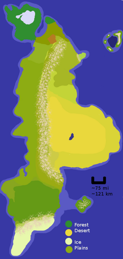
Wytn is the largest and best-documented continent of the planet Ŵadin. It is home to many different climates and cultures, and was the first continent on Ŵadin to boast a human population.
Geography
The Humid North
The northern part of Ŵadin is humid and supports dense vegetation in the form of a rainforest as well as a curious crystal lake, the 'Freeze Sea'.
Notable Landmarks
The small stretch of land which connects the forested peninsula to the mainland is known in the local dialect as stro pa yehén /stro pa yiheɪn/ - 'land of the monsters'. It grows smaller with each passing year.
A large crystalline lake is located in the middle of the peninsula which constitutes the majority of the land upon which rainforest is found. The crystal covering the water beneath is nearly perfectly clear after rainstorms, but hazier and more opaque during dry spells. The exact nature of the crystal is unknown, but locals have drilled past it easily for centuries, even creating underwater air pockets which can be used as under-ground swimming chambers. The lake is known colloquially as the 'Freeze Sea'.
The Grassy North
To the east slightly and away from the main peninsula, there is another small forested area and then hilly grasslands.
Notable Landmarks
An area called mi gib dena, (/mi gib diˈna/) or 'the dank earth place' is notable for the fact that it has perpetually damp clay instead of soil for ground material.
The Desert Wastelands and their cousin plains
Further south, the beginnings of the Atland mountains can be seen. These stretch almost the entire length of the continent, some 1100 miles. As one continues south, they divide the desert wastelands from the relatively nice grasslands to the west. Due to their height, they are unscalable and impassable save for the Tiaman pass.
Notable Landmarks
A giant lake, the Ilmétric pool, has such a high salt content that the desert nomads actually harvest salt 'cubes' from its shores.
The South
Past where the desert ends to the east, on the west shore of the continent the grasslands grow lusher and more dense, until finally turning into a deciduous forest, which lasts most of the rest of the way down the continent until the last 300 miles or so, where the mountains again divide the land into two. Beyond the mountains is a very short icy area which has no known name.
Languages of Wytn
Baljek Tongues
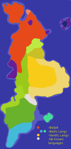
In the north (reddish areas on the map), Baljek Weyr is widely-spoken. Its stronghold is the enormous rainforest peninsula, though it has spread well beyond its original bounds and into the grasslands and mountains of the east.
The lighter-red area represents Talēli, an offshoot dialect which appeared due to The Audacity of Abial.
Baljek tongues are part of the greater Weyr family of languages, which includes the Pantrelan language and Klamek languages of the south.
Tongues of the Sandin
On the east coast, languages of the Sandin people (also known as the tréin kémanin) are wide-spread and thriving.
There are three large dialects of Sandic which merit mention: the large coastal area of light-orange represents the dialects of the kafédin, while the inland area of orange represents the dialect of the hijjagin, and the northernmost portion of orange shows the area of the speech of the étibikain.
Pantrelan and Klamek
The large green areas at the bottom of the map- and the lighter ones which stretch further up through the middle of the continent- are meant to represent the area of the Klamek and Pantrelan languages and dialects. Pantrelan, the largest and darkest area of green on the map, still inhabits the oldest (and original) home of the Weyr Languages.
Its daughter languages and dialects, usually referred to as Klamek (the word for 'horse', as most people who speak those languages are in constant contact with the animals) have spread northward and live in the northern plains and mountain ranges.
The great Badis
Badis languages (purple and bluish areas on the map) were previously the most widely-spread languages on Wytn. Though they have fallen into disuse over much of their previous range, there are still communities which use them on a day-to-day basis- see the small peninsula and the volcanic islands of Atasia, and the areas on the west coast.
Distantly related to the Badis languages are the languages Ek kaiatan and Island. The three language groups share a common ancestor, Pareš, but have been separated for so long that they now hardly resemble one another any longer.
The issue of Island
Being that the Island languages (represented by the teal-colored blob out in the middle of the ocean) were so long separated from the shore, and that both Weyr and Pareš were spoken there, the language has understandably come to have traits of both mother tongues. The majority of Island's vocabulary comes from Weyr languages, but its grammar is uniquely Pareš.
As a result, there has been some controversy as to how to classify Island. Traditionally it was considered to be part of the Weyr family of languages, however nowadays it is commonly found listed with the Pareš -descended tongues.

