Aarð: Difference between revisions
(Updated list of locales) |
No edit summary |
||
| (37 intermediate revisions by one other user not shown) | |||
| Line 1: | Line 1: | ||
{{Planet| | |||
== | |name=Aarð | ||
=== | |image=[[Image:Aarð3.png|300 px]] | ||
|distance=0.7834 AU | |||
|year_local=260.0 Aarði days | |||
|year_earthdays=253.263815 earth days | |||
|siderealday=23.5026976 hours | |||
|solarday=23.37819831 hours | |||
|diameter_metric=13,072 km | |||
: | |diameter_usa=8,124 mi | ||
|area_metric=536,826,505.9 km<sup>2</sup> | |||
|area_usa=207,343,154.8 mi<sup>2</sup> | |||
|tilt=19.277382 degrees | |||
|mass_metric=6021.2 Yg | |||
|mass_earths=1.007968394 earths | |||
|gravity=9.40687056 m/s<sup>2</sup> | |||
|moons=2 ([[Cetí]] and [[Tiró]])}} | |||
'''Aarð''' is a conworld created by [[User:Navidel|Navidel]]. The planet is 13072 km (approximately 8124 US miles or 2442.81 [[Aarði measurement|great leagues]]) in diameter. Aarð, whose name comes from an [[Aasti]] word meaning Earth, is the second planet from its parent star, a main sequence class G9 with a mass of 0.8501 solar masses. It is technically a binary planet, orbited by a body known as [[Tiró]] that is .97 times its mass. A smaller moon known as [[Cetí]] orbits around both bodies (technically, the barycenter). The Aarð-Tiró system shares its sun with several other planets, including [[Luariaþ]], a small, hot rocky planet thats orbits closer to the sun than Aarð does; [[Odonor]], and several more distant planets. | |||
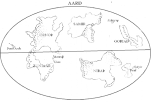
[[Þeal]], a small continent on the lower right of the map, is the most highly developed part of Aarð. Other landmasses seen on the map include [[Ornoþ]] (upper left), [[Samir]] (top center), [[Goriað]] (upper right), [[Zuniaar]] (lower left), [[Niraþ]] (west of Þeal), and the islands of [[Saiïc|Saiyic]] (east of Þeal), Soktareŋ (west of Goriað), Astaraþ and Cion (between Ornoþ and Zuniaar), and the Þanit archipelago (far left of map). | |||
[[Category: Aarð]] | |||
[[Category: Conworlds]] | |||
[[Category: Planets]] | |||
Latest revision as of 11:13, 28 October 2011
| Aarð | |
|---|---|

| |
| Distance from sun: | 0.7834 AU |
| Year length: | 260.0 Aarði days |
| (253.263815 earth days) | |
| Sidereal day: | 23.5026976 hours |
| Solar day: | 23.37819831 hours |
| Diameter: | 13,072 km |
| (8,124 mi) | |
| Surface area: | 536,826,505.9 km2 |
| (207,343,154.8 mi2) | |
| Axial tilt: | 19.277382 degrees |
| Mass: | 6021.2 Yg |
| (1.007968394 earths) | |
| Gravity: | 9.40687056 m/s2 |
| Number of moons: | 2 (Cetí and Tiró) |
Aarð is a conworld created by Navidel. The planet is 13072 km (approximately 8124 US miles or 2442.81 great leagues) in diameter. Aarð, whose name comes from an Aasti word meaning Earth, is the second planet from its parent star, a main sequence class G9 with a mass of 0.8501 solar masses. It is technically a binary planet, orbited by a body known as Tiró that is .97 times its mass. A smaller moon known as Cetí orbits around both bodies (technically, the barycenter). The Aarð-Tiró system shares its sun with several other planets, including Luariaþ, a small, hot rocky planet thats orbits closer to the sun than Aarð does; Odonor, and several more distant planets.
Þeal, a small continent on the lower right of the map, is the most highly developed part of Aarð. Other landmasses seen on the map include Ornoþ (upper left), Samir (top center), Goriað (upper right), Zuniaar (lower left), Niraþ (west of Þeal), and the islands of Saiyic (east of Þeal), Soktareŋ (west of Goriað), Astaraþ and Cion (between Ornoþ and Zuniaar), and the Þanit archipelago (far left of map).