Wytn: Difference between revisions
No edit summary |
No edit summary |
||
| Line 9: | Line 9: | ||
===Notable Landmarks=== | ===Notable Landmarks=== | ||
The small stretch of land which connects the forested peninsula to the mainland is known in the local dialect as 'stro pa yehén'- 'land of the monsters'. It grows smaller with each passing year. | The small stretch of land which connects the forested peninsula to the mainland is known in the local dialect as ''stro pa yehén'' /stro pa yiheɪn/ - 'land of the monsters'. It grows smaller with each passing year. | ||
A large crystalline lake is located in the middle of the peninsula which constitutes the majority of the land upon which rainforest is found. The crystal covering the water beneath is nearly perfectly clear after rainstorms, but hazier and more opaque during dry spells. The exact nature of the crystal is unknown, but locals have drilled past it easily for centuries, even creating underwater air pockets. The lake is known colloquially as the 'Freeze Sea'. | A large crystalline lake is located in the middle of the peninsula which constitutes the majority of the land upon which rainforest is found. The crystal covering the water beneath is nearly perfectly clear after rainstorms, but hazier and more opaque during dry spells. The exact nature of the crystal is unknown, but locals have drilled past it easily for centuries, even creating underwater air pockets which can be used as under-ground swimming chambers. The lake is known colloquially as the 'Freeze Sea'. | ||
==The Grassy North== | ==The Grassy North== | ||
| Line 17: | Line 17: | ||
===Notable Landmarks=== | ===Notable Landmarks=== | ||
An area called 'mi gib dena', or 'the dank earth place' is notable for the fact that it has perpetually damp clay instead of soil for ground material. | An area called ''mi gib dena'', (/mi gib diˈna/) or 'the dank earth place' is notable for the fact that it has perpetually damp clay instead of soil for ground material. | ||
==The Desert Wastelands and their cousin plains== | ==The Desert Wastelands and their cousin plains== | ||
Revision as of 06:58, 17 July 2011
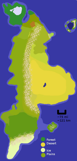
Wytn is the largest and best-documented continent of the planet Ŵadin. It is home to many different climates and cultures, and is believed to be the first continent on this planet to have been colonised by human-form sentients.
Geography
The Humid North
The northern part of Ŵadin is humid and supports dense vegetation in the form of a rainforest as well as a curious crystal lake, the 'Freeze Sea'.
Notable Landmarks
The small stretch of land which connects the forested peninsula to the mainland is known in the local dialect as stro pa yehén /stro pa yiheɪn/ - 'land of the monsters'. It grows smaller with each passing year.
A large crystalline lake is located in the middle of the peninsula which constitutes the majority of the land upon which rainforest is found. The crystal covering the water beneath is nearly perfectly clear after rainstorms, but hazier and more opaque during dry spells. The exact nature of the crystal is unknown, but locals have drilled past it easily for centuries, even creating underwater air pockets which can be used as under-ground swimming chambers. The lake is known colloquially as the 'Freeze Sea'.
The Grassy North
To the east slightly and away from the main peninsula, there is another small forested area and then hilly grasslands.
Notable Landmarks
An area called mi gib dena, (/mi gib diˈna/) or 'the dank earth place' is notable for the fact that it has perpetually damp clay instead of soil for ground material.
The Desert Wastelands and their cousin plains
Further south, the beginnings of the Atland mountains can be seen. These stretch almost the entire length of the continent, some 1100 miles. As one continues south, they divide the desert wastelands from the relatively nice grasslands to the west. Due to their height, they are unscalable and impassable save for the Tiaman pass.
Notable Landmarks
A giant lake, the Ilmétric pool, has such a high salt content that the desert nomads actually harvest salt 'cubes' from its shores.
The South
Past where the desert ends to the east, on the west shore of the continent the grasslands grow lusher and more dense, until finally turning into a deciduous forest, which lasts most of the rest of the way down the continent until the last 300 miles or so, where the mountains again divide the land into two. Beyond the mountains is a very short icy area which has no known name.
